|
|
|
|
 |
|
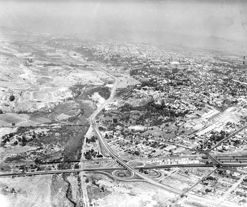
The Photo is the old Highway
junction at old 101 Pacific Coast & Hwy 8
or back then we might of call it 80. You can
see the Presidio Mission in the background at
the old Town Park. We use to slide down there
on dry ice. My Dad and Gramps worked for
Challenge Dairy back then just east on old 80.
We on the same thought? -- Frank Greiner ‘69
I hope you get back to all of us on the
location of the aerial photo in San Diego. My
guess is the juncture of Route 5 and the 8 ---
It looks like it may have been taken just over
the Mission Valley area. Actually, I guess
that would have been the 101 and Route 8! (the
route name hadn't been changed yet!) Can't
wait to find out! Thanks! -- Gloria Peckham Mercier '67
All I can figure is that it is Old Town
looking east. I didn't know US101 and HWY 80
had a 3/4 clover leaf. The interstate system
was many years away. Was Pacific Highway
actually US101 there? -- Mike Fry ’60
Thanks for including an old aerial photo of
San Diego in 1946. I love old shots of the
city and aerial views, especially. I
immediately recognized the view looking east
up Mission Valley. The Presidio Mission is
nearly dead center in the shot. The part that
amazed me was that there was actually a
cloverleaf interchange from US Hwy 80 in the
foreground. I would have bet that there was no
such thing in San Diego that long ago – Owen
“Wes” Western ’63
Thanks for sharing the photo of Mission
Valley. I can see where I lived as a child in
the government housing next to Juan St. It is
now the Heritage Park with old historic homes
and buildings -- Bruce Parker ' 62
The Howard Rozelle photo is the junction of US
80 and PCH (101) looking east up Mission
Valley. Mission Hills, the Presidio, and Old
Town are clearly visible as well as the Santa
Fe RR Morena Blvd (to the far left) is a
secondary road leading to the new community
(just out of view) of Linda Vista where I was
raised until 7 yrs old. To the far right (just
out of view) was the Arrowhead Water Co. plant
(Washington and Hancock) where my Dad worked
for 35 years. Ahhh, the old days -- Rodger
Gredvig '64
The air photo is great--looking
east up Mission Valley with the Presidio in
the nearer part. I'm surprised there already
was a cloverleaf in 1946. My folks moved back
to San Diego (from DC) in 1947 and we lived in
former Navy housing east of Midway Drive, near
where the Sports Arena is now. We called it
Aztec Villa--entirely occupied by SDSC
faculty, waiting for post-war housing to be
built. I remember the long drive to San Diego
State along a two-lane road that hugged the
south edge of Mission Valley, but I have no
recollection of the "freeway" portion visible
in the photo. I also was surprised to see the
east-west streets on the mesa stubbing out
near the north edge (south side of the
valley), but on checking a street map I see
that indeed they do (Madison Ave especially).
I went to Midway Elementary School (no trace
remains) for Kindergarten and First grade,
then to the Campus Lab School. One of these
days maybe I'll scan my Kindergarten class
photo and send it to you. For some reason I
don't have one from First grade, and for some
other reason the Campus Lab School didn't have
them until Fourth grade, so there's a
three-year gap in my childhood. My most vivid
memory from Midway was in Kindergarten going
out on to the playground on the south side of
school (all paved, of course, in the San Diego
tradition) in order to see what I remember as
the last ever flight out from Lindbergh of a
B-36, probably in 1948 (but according to
Wikipedia they first flew in 1948, so my
memory of the reason for us being out there
may be flawed). It was really scary--I swear I
could see the rivets as if flew right over
us--they gained altitude very slowly. Thanks
again for making Friday extra fun.
--Bob Richardson '61
OOOOOhhhh, a game? Name that
part of San Diego? No wonder I'm lost when I
go home. Intersection of the 8 and 5 in the
foreground. Mission Valley on the left. Cliffs
in the middle right side are North Park/ Meade
St/33rd area/ Is that Westwick(??) Park that I
see (I could go find that old Park and
Recreation Dance program from 1958 for it's
spelling. My brother witnessed that long,
long. longest baseball game there. I should
print this and sent it to my brother (Hoover
'59). This is fun - do more -- Jean Schweikhard Mueller
(should have been '71 became a San Dieguito
Mustang)
(Apparently there WAS a
cloverleaf in 1946. Susie Johnson Martin
'71 shares a Highway
101 web site)
|
|
|
|
|
|
|