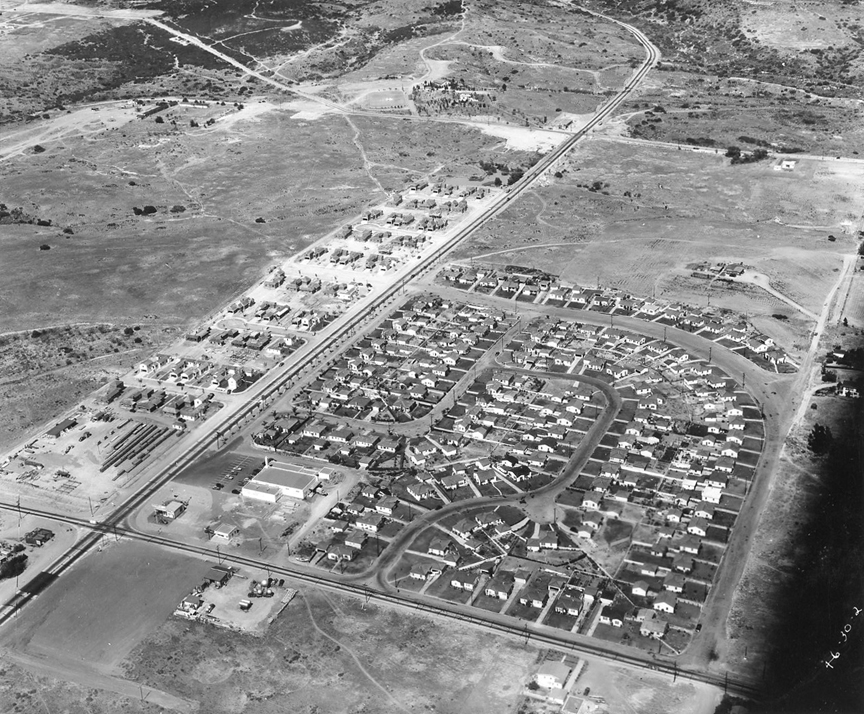
| I'M
HOPING THAT, despite the small area pictured,
the fact that homes are being constructed near
what appears to be a major intersection will
help someone locate this 1946 Erickson &
Rozelle aerial.
It
is looking east from the corner of 47th
& Federal. Those streets in the
subdivision are Beech, Lyon, & Duval. On
the right is the shadow of the canyon where
94 will later be – Betty
Mayfield Picard ‘75
You
must understand, as a retired geographer I
take these things very hard. I finally was
checking data by census tract from the 1990
Census of Housing, which in the sample data
portion gives housing units built for
various time periods. Tract 34.02 had one of
the larger numbers for 1940-49 so I pored
over it and finally found where we are in
the photo. The view is roughly to the
northeast. The major intersection in the
lower left is where 47th St. and Federal
Blvd. meet. I was faked out by the
orientation--the shadows aren't very long so
I was thinking they pointed north, but
they're aimed almost due east. Must have
been taken near the summer solstice for the
sun to be that high still in the afternoon.
I noticed that these new houses have the
garage at the back of the lot, with the
driveway running down the side to them. That
was pretty much gone by the 1950's I think.
I just checked and see that Rozelle
#16 shows the same area, but looking
to the west and ten years later with Highway
94 under construction. Lots of change in ten
years -- Bob
Richardson
'61
|
|
|