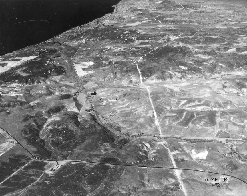
| I'VE REJECTED THIS ROZELLE
AERIAL several times because it is an infrared
shot taken at such a high altitude that it
makes San Diego County look like the moon. I
went ahead and scanned it, then looked on the
back. It was taken January 8, 1961 and is
Negative #13648. It turns out to be a pretty
good mystery photo, and the negative number
helps analyze last week's photo.
The Rozelle photo depicts
Sorrento Valley running to the northwest and
Miramar Road running east/west...the round
building in the left center of the photo is
General Atomics...Torrey Pines golf course
is visible on the left side and the bridge
to Del Mar on Highway 101 runs north along
the coast -- Gary Morris '61
That's Miramar Rd in the foreground, and the
jagged line running along the future route
of I-805 is a high voltage transmission line
(it's still there). You can see the railroad
in Sorrento Valley, alongside Sorrento
Valley Rd. Torrey Pines Golf Course is very
white in infrared. Just below the golf
course is the round building of General
Atomic. It was one of the first buildings on
the Mesa. The lone building in the lower
left is right where University Town Center
is now. It might be left over from the Camp
Mathews Marine base -- Mike Fry '60.
Hello Sorrento Valley! What a
pre-civilization photo! General Atomics on
the left, the “old” Miramar Road on the
bottom (great for avoiding delays in Rose
Canyon on 101 on a Sunday when heading
North). At first I thought the thin white
line going up the center was an early
engineering path for 5 and 805, but then I
saw the white “mounds” to the right of the
race track, which we now know as I-5, but
CalTrans let the dirt settle for a few years
before paving the roadway, so the white line
must be a high voltage line. Would love to
know what building is just sitting there,
all by its little old self, on Miramar Road
-- Earl Feldman ‘61
|
|
|